"The English winter, ending in July, to recommence in August." - Lord Byron
August was actually a very average month, both in terms of temperature and rainfall and it was also warmer than July. The majority of sites in Cumbria recorded marginal departures from the norm', be that positive or negative for both elements - but, despite all this and being 'average', overall, due to the month having been of the 'unsettled type' it would be classed has having been on the poor side and like this summer, one that never really happened.
Temperatures were often below average, especially by day, with 21 days failing to attain the mean maximum temperature of 18.5°c, (only 5 days managed 20°c) and it was certainly cool through the middle part of the month, before a few brief warmer days (19th-23rd). Day-time temperatures then fell away below average for the last week of the month although under predominantly cloudy skies night-time minima remained well above.
MSLP of 1012.6 Mb was -1.5 Mb below the average for August with low pressure once again in the ascendancy with high pressure still marginalised to the rare and inconsequential visits.
Overall a mean minimum of 10.32°c and a mean maximum of 18.28°c saw the temperature 0.3°c below the 1981-2010 average, making it the warmest August since 2013. The highest maximum temperature recorded was 24.5°c (23rd), the lowest minimum 4.1°c (17th).
Rainfall of 97.0 mm (Crosby Ravensworth School 102.5 mm) made it the driest August since 2010 and here at Maulds Meaburn was 86% of average for 2007-14. Locally, apart from Newton Rigg which showed a large departure from the norm', rainfall was typically within a +/-2% of average.
At the Met' Office site at Newton Rigg, 103.0 mm (147 % and one of the higher percentages in the county) made it the driest August since 2013 and in a series back to 1914 this makes it the 25th wettest in that time (2 years of missing data). A mean temperature of 14.25°c is the warmest since 2013 and in a series back to 1951 makes it the 27th warmest.
Figures from the Environment Agency’s rainfall sites were, (figure in brackets being the monthly average for 1961-90) ‘Data kindly provided by the Hydrometry and Telemetry team of the Environment Agency (Penrith)’:
Kirkby Thore 70.4 mm (68.5 mm)
Brothers Water 197.9 mm (198 mm)
Nunwick Hall 90.2 mm (78.4 mm) and
230.2 mm at Seathwaite Farm (Borrowdale - 240 mm [average for 1981-2010]).
SUMMER
Here at Maulds Meaburn, summer 2015 with 211.4 mm of rain (Crosby Ravensworth 225.4 mm) has been the driest since 2010 and is the 2nd driest of the nine now recorded. That 211.4 mm represented just 69.4% of the rainfall for those 8 previous summers.
A mean temperature of 13.57°c is the coldest since 2012 and is the third coldest of the seven summers now recorded and the 13.57°c makes the summer of 2015 some 0.65°c colder than the average of those previous six.
This is all fairly similar to that at Newton Rigg which totalled 217.4 mm of rain (unusually a greater total than that of Maulds Meaburn) and had a mean temperature of 13.45°c. In comparison to the 1981-2010 averages this represented 109.3 % of summer rainfall and it was 0.75°c cooler than average.
This makes the summer of 2015 the 43rd wettest in a series back to 1914 (4yrs of missing data) and the 16th coldest, with one year also having the same mean temperature in a series back to 1951 (one year of missing data).
August
1st - 6th The month opened with low pressure (LP) dominant, the 1st though was a sunny and breezy day (rain in the early hours being credited back to the 31st July) as we managed to stay clear of any fronts, but LP (976 Mb on 3rd) to our southwest filled and moved north to the west of Eire and was still anchored in position on the 4th. Rainfall though was mainly limited to the 4th, but it was generally dull and cloudy which resulted in some mild nights.
The 2nd managed to remain relatively dry but cloudy and even the 3rd only saw some light rain and showers in the morning before the main belt of rain arrived overnight into the 4th. The 4th was a general write-off with moderate rain throughout the day, easing as the the LP finally drifted away north, to be replaced by a new, but weaker area of LP.
With the new LP, rainfall was limited to drizzle on a murky morning of the 6th, before high pressure (HP) tried to ridge in and the afternoon steadily progressed through to a sunny end.
7th - 8th A slack pressure gradient with HP ridging from the south-west gave a reasonable day on the 7th with some sunshine and which at 18.2°c was quite pleasant. The 8th though, under a now stronger ridge of HP, was the better of the two days, with more sunshine and warmer at 19.4°c before LP in the Atlantic once again pushed fronts our way.
9th - 10th The HP, now to our east, gave way to fronts trailing of the LP, however, apart from being overcast, rainfall was light and scattered and mainly limited to a few showers.
11th - 13th HP had begun to try and ridge in during the 10th, but that ridge became more dominant from the 11th, elongating, but as before, not lasting, although giving a few days of decent weather.
After a generally cloudy day on the 11th, both the 12-13th were fine sunny days with both attaining 20°, the 13th more than decent at 22.6°c (72.7°f). It had been a long wait for something warm and sunny, the last day prior to the 12th to hit 20° being the 16th July.
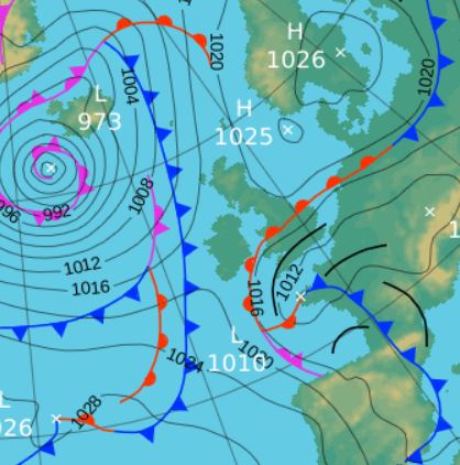
14th The HP from the two previous days had controlled our weather well into the evening of the 13th, but a notable area of LP had been building in Biscay and pushing north during the period and which had given some significant thunderstorms in the south of the country; it arrived in the north of the UK late evening on the 13th.
The LP had been drawing in warm and humid air from the continent into its circulation (Poland and Germany had been experiencing some extremely high temperatures), and this gave the mix for the intense downpours - but for us it just gave a wet and cold day and we didn't even get any thunder.
The rain became heavy overnight into the 14th, 17.7 mm being credited back to the 13th, the month's wettest day (we use 09-0900 GMT for rainfall) with a further 5.3 mm during the 14th. However, at just 14.4°c, the day was quite cool.
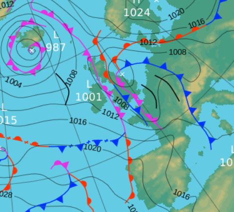
The synoptic charts below, both from mid-day on the respective days, show the HP hanging in on the 13th to give us the decent sunny day, but with the LP advancing north and bringing the rain overnight and during the 14th.
Mid-day 13th
 Mid-day 14th
15th - 18th HP then built in Biscay, ridging north and then moving north to be centred over Cumbria on the 17th before a further breakdown in the weather. It fell dry and calm with variable amounts of cloud but which still allowed for some sunnier interludes, however, there was a notable dip in the night-time minima during these days.
Temperatures remained suppressed on the 15-16th, but rose respectably to 19.7°c on the 17th, albeit after starting with the month's coldest temperature of 4.1°c (39.4°f). The HP weakened on the 18th and was replaced by fronts trailing off LP in the North Sea that was slowly tracking west and which gave a damp afternoon.
19th - 26th LP centred in the Atlantic that extended a series of fronts over the UK then became the dominant feature with showers or more organised bands of rain becoming common, although the heaviest of any rain tended to fall in the evenings.
However, the temperature initially rose at the start of this period with both the 20th and 21st nudging just over the 20°c and the 23rd peaked at a month's high of 24.5°c (76.1°f).
Whilst the few days enjoyed warmer temperatures those frontal systems also brought rain, some murkiness and apart from the 23rd, not too much sunshine. The evenings of the 19-20th were both murky and damp and then the 21st and 22nd saw spells of moderately heavy rain in the evening. The rain on the 21st was brought by the passage of a pair of cold fronts and that of the 22nd courtesy of a strung out waving front that occluded and became semi-static and which brought very heavy rain in the southwest of the UK.
The 23rd was a fine sunny and warm day if windy, as we stayed just clear of that wave front. However, the evening saw another cold front push west and the heavens opened (15.5 mm of rain) and we had a spell of very heavy rain with a few rumbles of thunder.
It then became fresher from the 25th with sunny intervals and a few blustery showers, but with mild nights.
27th - 31st HP in Biscay then started to build and become the dominant feature in the Atlantic, but LP was also never too far away, but there was a slight improvement in the weather, if not an increase in temperature.
With LP to the north-west on the UK on the 27-28th and the HP to our south there was a brisk south-westerly flow and the days were notably windy, but with sunny intervals.
The month then ended on a 'cloudy but bright' note with us stuck between the HP in the Atlantic and LP to our east and north, that saw the winds swing north-westerly on the 31st and the temperature begin to dip.
Rainfall totalled 97.0 mm for the month, with rain recorded on 22 days of which 18 were 'Wet days' (1.0mm +).
The Mean Temperature for the month was 14.30°c -- The Mean Max' was 18.28°c -- The Mean Min' 10.32°c.
We had 0 Air Frosts in the month (year 42) -- Grass frosts totalled 0 (year 92).
The 1 foot soil temp ranged from a low of 14.6°c on the 18th to a high of 17.3°c on the 24-25th -- with a monthly mean of 15.4°c
The 1 meter soil temp ranged from a low of 13.3°c on the 2nd -4th to a high of 14.2°c on the 28-29th -- with a monthly mean of 13.6°c
COMPARISONS:-
* August 2015 rainfall was 86% of the August average for 2007 - 2014
* August 2015 was 0.2°c warmer than the August average for 2009 - 2014 and 0.3°c colder than the local long term average 1981-2010
* 2014 Jan - Aug TEMP 9.96°c -- RAIN 959.9 mm
* 2013 Jan - Aug TEMP' 8.55°c -- RAIN 634.9 mm
* 2012 Jan - Aug TEMP' 8.97°c -- RAIN 744.8 mm
* 2011 Jan - Aug TEMP' 9.20°c -- RAIN 777.6 mm
* 2010 Jan - Aug TEMP' 8.26°c -- RAIN 373.2 mm
* 2009 Jan - Aug TEMP' 9.44°c -- RAIN 760.3 mm
* 2008 Jan - Aug TEMP' -- RAIN 861.7 mm
This makes the Jan' to August period of 2015 0.44°c colder than the average for 2009-14 and with 103.2% of average rainfall for 2008-14
JANUARY 2010
FEBRUARY 2010
MARCH 2010
APRIL 2010
MAY 2010
JUNE 2010
JULY 2010
AUGUST 2010
SEPTEMBER 2010
OCTOBER 2010
NOVEMBER 2010
DECEMBER 2010
JANUARY 2011
FEBRUARY 2011
MARCH 2011
APRIL 2011
MAY 2011
JUNE 2011
JULY 2011
AUGUST 2011
SEPTEMBER 2011
OCTOBER 2011
NOVEMBER 2011
DECEMBER 2011
JANUARY 2012
FEBRUARY 2012
MARCH 2012
APRIL 2012
MAY 2012
JUNE 2012
JULY 2012
AUGUST 2012
SEPTEMBER 2012
OCTOBER 2012
NOVEMBER 2012
DECEMBER 2012
SUMMER 2012
REVIEW OF 2012
JANUARY 2013
FEBRUARY 2013
MARCH 2013
APRIL 2013
MAY 2013
JUNE 2013
JULY 2013
AUGUST 2013
SEPTEMBER 2013
OCTOBER 2013
NOVEMBER 2013
DECEMBER 2013
REVIEW OF 2013
JANUARY 2014
FEBRUARY 2014
MARCH 2014
APRIL 2014
MAY 2014
JUNE 2014
JULY 2014
AUGUST 2014
SEPTEMBER 2014
OCTOBER 2014
NOVEMBER 2014
DECEMBER 2014
WINTER 2014
REVIEW OF 2014
JANUARY 2015
FEBRUARY 2015
MARCH 2015
APRIL 2015
MAY 2015
JUNE 2015
JULY 2015
© Darren Rogers 2015
Want to comment on this site? email